
This Seshnegi map dates to the reign of King Lofting IV of Seshnela. It displays many hallmarks of Rokari map-making, being highly stylised with geometric curves and straight lines and the west being oriented towards the top of the map, pointing to the location of the primeval Land of Logic.
The map displays no political borders, nor geographical precision, making the map useless for exploration or martial endeavours. It was likely that this map was produced for a trading house.
While originally coloured with rich pigments, the lack of any writing suggests it was for use by illiterate merchants. Settlements are instead marked with small coloured circles, with particularly important cities being marked with a rune indicating a particularly important resource located there.
Also included on the map are four mountains. Three are marked with stasis runes, referring to the dwarven held Iron mountains to the south, and the Nidan mountains to the north. The last mountain is marked with the darkness rune, indicating it represents the Uzgor mountains, and specifically Vulture's Peak.
The western islands of Old Seshnela have been to three, likely the three great islands of Pasos: Varskolin, Volonne, and Culonmac.
The Southern Reaches
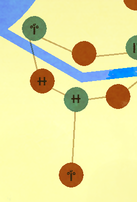
While covering many different provinces, this is one of the most compressed areas of the map, with the rivalry and occasional wars between Seshnela and the Quinpolic League being completely ignored. Likely, the author of the map rarely came to the southern reaches of Seshnela, leaving him to consult on earlier maps.
From left to right, top to bottom:
Amneleon - This town can be identified by the use of the plant rune, referring to Amneleon's control over Seshnela's Tea production.
Unknown - Likely Urfenoswal, due to its administrative role over southern Seshnela.
Hathwal - Primarily identified from its famous Floating Markets, indicated by the trade rune.
Noloswal - One of the greatest port towns in Genertela, Noloswal recieves little acknowledgement from this map, being notified only by a trade rune. This is part of what cement's this map's Seshnegi origins.
Unknown - Likely Rinalket, a border town between the Quinpolic League and the Kingdom of Seshnela.
Sreborket - The plant rune likely indicates either the sorcerous gardens devised by the city's wizards, or its role in harvesting lumber from Tarinwood.
The Iron Path

Quite possibly the most important trade route in Genertela, this path from Rhis to Relamorket involves a dangerous and exhausting trek through the forested highlands of Noyelle. Many merchants have been forced to turn back by beast-folk who dwell in the highlands, but many more still risk the journey, for the sake of purchasing iron.
From top to bottom:
Rhis - Part of the Castle Coast, Rhis is famous for being the only place where dwarves are willing to trade iron, indicated by this town's death rune.
Priina - The seat of power for the Count of Deu, this city was presumably little more than a resting place for this map's author.
Voi - The harmony rune refers to this city's ancient Xemelan temple and healing springs.
Relamorket - Located at the convergence of the Tanier and Deu rivers, Relamorket is a major crossroads in Seshnela.
The Heartland

This stretch of the upper Tanisor and southern Rindland has been expanded, presumably the result of the map's author's familiarity with this region increasing it's importance. This region is home to many rich wheat farms, compared to the lower reaches' rice paddies.
From left to right:
Arnlor - This city is home to both the treasury and royal mint, making it the source of Silver Imperials found all over Seshnela and Safelster. The city is also home to many powerful guilds, making this a likely origin for the map's author, and explaining it being signified by the trade rune.
Vetagane - While unmarked, Vetagane is easily identified as the only major settlement between Arnlor and Segurane.
Segurane - Painted in faded gold and bearing the mastery rune, Segurane of the Walls is easy to identify. Within the outermost wall lies the great markets and homes of crafters and merchants, making this one of the greatest centres of trade in Seshnela.
The Safelstran March

The borderlands between Seshnela and Safelster are fraught with danger, over the rivalries between the kingdom and the city states, but also extremely valuable. Ironically, since the Opening, the direction of trade has shifted, since it is now far cheaper to ship goods overseas instead of passing along the Manirian Road.
From top to bottom:
Fornalor - This city is home to some of the greatest stables in the west. The horse breeders here are notoriously exacting, breeding and selling horses that bear the noble colours of black, white, and grey.
Leplain - Painted in azure and marked with the law rune, this is obviously Leplain, city of wizards, and home to the greatest libraries outside of the city of Sog. The markets outside of the Blue Temple are always full of rare goods, for the Ekozite School of Alchemy both needs and produces some of the strangest items in Glorantha.
Dangk - This city is located near to Hrelar Amali, the ancient ruins worshipped by barbarians as the city of the gods. Many pagans still make pilgrimages to the ruins, making Dangk's markets full of foreign, if crude, goods.
Heswal - The trade rune here is an interesting case, for Heswal is more infamously known for the toll placed on all goods going between Seshnela and Safelster. However, on the shores of the river before the island city, merchants have created a shanty market for trading goods, hoping to make extra profit before they need to pay the toll.
Kustria - The death rune marking this city refers to the Great Tournament held here each year. The need for new arms and weapons marks this city as an excellent place to trade oxhides of bronze for other goods.
The North

This region was once the heart of Arkat's Dark Empire, but ever since the empire fell, the land turned to wilderness. Although reclaimed by a succession of Seshnegi monarchs, much of the land is still unsuitable for wheat and rice, leading it to become the home of rye fields and sheep pastures.
From left to right:
Ukos - The death rune helps signify this town, and refers to its swordsmiths, who are the best in all Seshnela, with their bronze blades being sought after even in far off lands.
Isarnos - While not marked with any rune of importance, Isarnos does have a market, where they trade in devices copied from dwarven plans by adventurous (and somewhat foolish) wizards.
Harsad - Harsad was built to guard over the ruins of Arkhome, and guard it from barbarian grave robbers and Arkati sorcerers. Despite the best efforts of the town's soldiers and wizards, there still exists a black market for Arkati goods within the town.
Xeinar - The southmost point on the Old Imperial Road between Seshnela and Fronela, Xeinar has never profited from this trade. This is because, due to the ancient rituals involved in taking the road, the inhabitants of this town never interact with those travelling between the two nations.
Far Tarins

This province of Loskalm being appearing on the map helps cement the dating of it to Lofting IV's reign, since it was only freed from the ban a mere eight years before his reign, and there would be little land trade between Seshnela and Tarins for years afterwards. This may in fact be the earliest Seshnegi map after the Ban and Opening to show the province.
From top to bottom:
Southpoint - The law rune helps identify this city as the home of the High Watcher of Hrestolism. Despite this, the author's Rokari bias can be seen by treating Southpoint as just another city, without the azure given to Leplain.
Isefwal - Once almost deserted, Isefwal grew into a thriving port once the Opening of the Oceans took place. It's role as the entryway for goods into Loskalm is noted by the trade rune.
Unknown - While likely Tarnwall, this may instead be Omphis, with no identifying symbols to hide that city's role in teaching Men-of-All, considered blasphemous by Rokari.
Midtasker - Although an important Tarins city, Midtasker receives little acknowledgement here, possible reasons include the author distrusting the ancient graves found here, it's importance to the old Middle Sea Empire of the second age, or a disagreement with a local merchant.
Svenlos - Svenlos is the northern edge of the Old Imperial Road, the only safe route through the dangerous Erontree forest. While surrounded by orchards, little of that is recorded here.
Special thanks to Kalin Kadiev for improving the appearance of the map.
No comments:
Post a Comment